Space-based Geospatial Intelligence

Decision Support for Mining activities

Comprehensive Solutions for Land Acquisition

Intelligent Monitoring of Mining Activities

Eco-Friendly Mine Reclamation

PRECISE
ACCURATE
RELIABLE

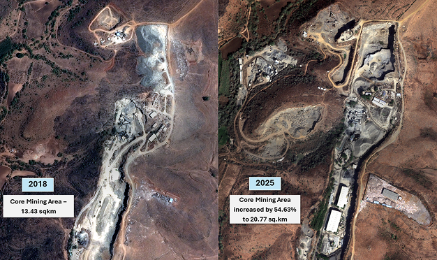
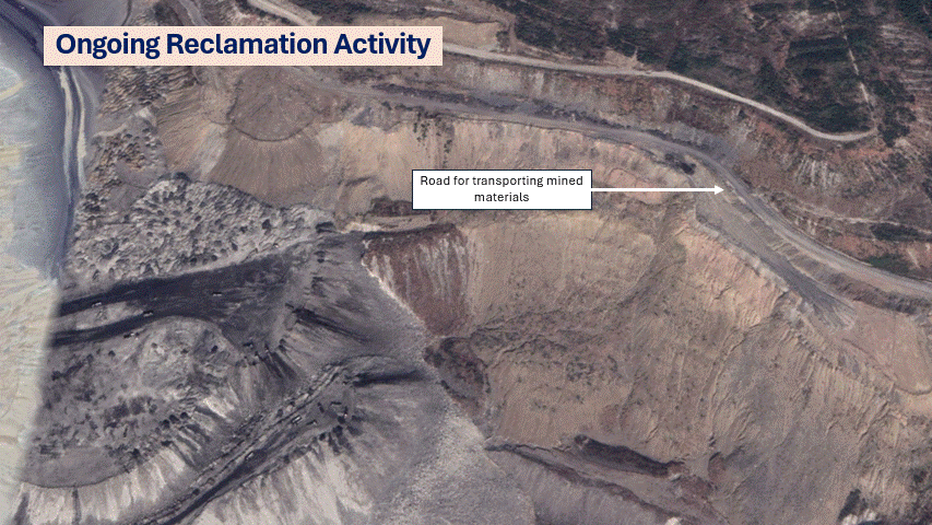
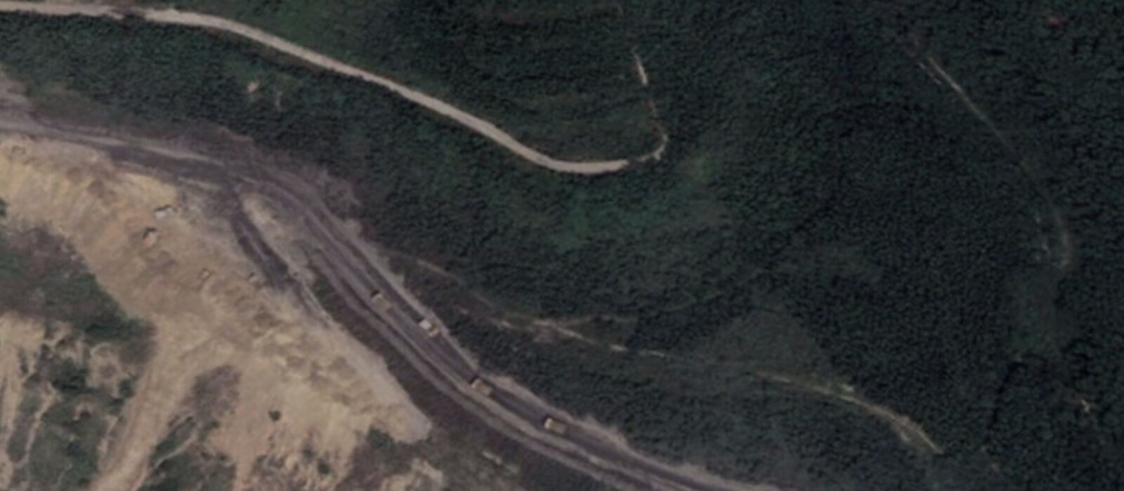
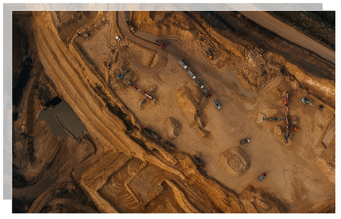
Geo-Intelligence for Smarter Mining

SPACEMINE AI is at the forefront of transforming the mineral exploration and mining industry through the integration of advanced space-based technologies and artificial intelligence. Our comprehensive platform focuses on three core components: Land Acquisition, Monitoring Mining Activities, and Mine Reclamation.

By leveraging high-resolution satellite imagery and sophisticated geospatial data, SPACEMINE AI offers innovative solutions for efficient and sustainable mining operations, including support for socio-economic impact analysis in land acquisition.

Land Acquisition

Precision from Above

SPACEMINE AI enhances the land acquisition process by utilizing very high-resolution satellite imagery and advanced geospatial data generation. Our platform produces detailed GIS maps that provide insights into structures, agriculture, plantations, water bodies, forests, and other land use categories. By combining cadastral maps and revenue data with satellite imagery, we offer a comprehensive view that supports informed decision-making. Additionally, mobile applications facilitate field verification and attribute data collection, ensuring accuracy and efficiency.
Detailed Urban & Agricultural Landscape
Houses, Homesteads, Roads and Fields
Bridge, Gabled Roofs, Trees and Flat-Roofed Buildings
Distinct Roofs with Water Tanks, Trees & Harvest Heaps
Outdoor Vehicle Parking Area with Vehicles Clearly Visible
Precision in measuring field areas.
View of a campus with yellow buses, buildings, and sports fields
Business area with buildings, solar-panel roofs, tree clusters, and barren land.
Solar Farm Near Urban Residential Area with Panels and Buildings Visible
Urban Residential Area with High-Rise Structures and Recreational Facilities

Highlights:

  1. Acquire high-resolution satellite data aligned with the land acquisition notification date.
  2. Develop a comprehensive GIS map detailing all physical structures, trees, plantations, agricultural crop types and statuses for each land parcel (including fallow land), forest land, water bodies, and other relevant features, complete with attributes for each area.
  3. Integrate cadastral maps and link the Record of Rights (ROR) to each feature for socio-economic impact analysis. Additionally, ensure that satellite data acquisition timestamps (date and time) are used as legitimate documents to support fair compensation.
  4. Utilize a mobile application for verification, collecting socio-economic data, and integrating it with the GIS map for comprehensive impact analysis.

Monitoring Mining Activities

Eyes on Every Operation

INTELLLIGENT MONITORING

Employ intelligent monitoring systems to ensure compliance and efficiency in mining operations. Our technology provides accurate and timely data to prevent unauthorized activities and optimize mining processes.

Utilize very high-resolution satellite data to monitor open cast mining operations at regular intervals.

DATA ANALYSIS

Analyze satellite data to provide insights and recommendations for improving mining operations and minimizing environmental impact.

REPORTING AND ALERTS

Generate legitimate reports and alerts regarding unauthorized mining activities, including geo-coordinates and area extent of any transgressions beyond leased boundaries.

Mine Reclamation

Restoring the Balance

Implement detailed and effective reclamation plans to restore mined areas, ensuring sustainable and eco-friendly development. Our approach integrates geospatial analysis, environmental assessment, and innovative techniques.

  • Reclamation Planning: Create detailed plans for mine reclamation that incorporate geospatial analysis, soil quality assessment, water management, and suitable vegetation types.
  • Ongoing Monitoring: Regularly assess reclamation efforts by acquiring high-resolution satellite data at specific intervals. Overlay reclamation plans to provide comprehensive reports for management and regulatory authorities.

Benefits

Discover the numerous benefits of SpaceMineAI's innovative platform, designed to improve decision-making and promote sustainable practices in mining.

Enhanced Decision-Making:

Use of advanced geospatial data for informed land acquisition and monitoring.

Sustainable Practices:

Commitment to environmentally responsible mining and reclamation processes.

Regulatory Compliance:

Facilitate adherence to regulatory standards through detailed reporting and monitoring.